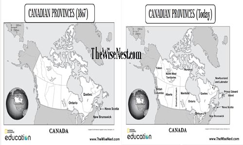
For Geography, this week we will be studying Canada. I have made a couple of maps to use with the kids. I made the maps using the mapping feature on the National Geographic website.
Have you tried it? It is amazing!!! You can choose which area of the world you want to make a map of, select the features you want highlighted, add your own labels… I am so excited to be able to use this feature and make my own maps! If you want to give it a try, click here and have fun for a little while. 🙂
Here are the maps I made. I made one with the provinces from 1867 and then another map with all the current provinces and territories. Enjoy!
join the conversation